“THE RE-CYCLE CORRIDOR”:
AN ECO-INDUSTRIAL THEME FOR
TRAIN AVENUE
AND THE WALWORTH RUN
CORRIDOR
PDD 611 Planning Capstone,
Spring 2004
Cleveland State University,
Levin College of Urban Affairs
Dr Wendy Kellogg, Instructor
Group Members: Jake Baker,
Ian DeGalan, Matt Grabenstein, Ann Kopac,
Marc Lefkowitz, Katharyne
Marcus, and Rick Seifritz
Final Report
Submitted:
May 11, 2004
I. Mission
Statement
Acknowledging, past planning practices have emphasized obsolete
technologies and values no longer applicable to Train Avenue; and further
Acknowledging, that these practices have created and encouraged dislocated communities and environmental degradation; and further
Acknowledging, that in the coming decades, environmental preservation and energy creation and conservation will be among the most important issues on a local, regional, national, and global scale;
Resolves,
that in order to remain viable it
is necessary to anticipate and plan for sustainable communities; and
Adopts,
the following guiding principles:
Ø Assuming the re-emergence of the Central Business
District as an organizing Unit:
o Viable Communities in close proximity to the CBD
will be the most efficient unit for the conservation of energy
o In order to encourage those communities the current
dislocations caused by existing infrastructure must be circumvented, or
changed, to connect those communities.
o Alternative forms of transportation must be
encouraged
o Business practice and form must be consistent with
self sustaining goals
o A community of mixed uses—residential, retail,
industrial, recreational—will be most likely to survive, and thrive, during
periods of economic change
o Natural systems should as much as possible influence
new development and planning to strive for a sustainable urban ecology that
appreciates the past, and recognizes that natural systems are often the most
enduring and efficient
o Enduring Communities are created by Communities,
public participation is encouraged and plans not considered by a majority of
active constituents should be reconsidered
II. Introduction
Project Area
This project
attempts to identify the health and development potential for the Train Avenue
area on Cleveland’s west side, referred to as the Walworth Run Corridor. In its entirety, the Corridor extends along
Train Ave from its intersection with Clark Ave (near West 61st St),
beneath the W 41st St bridge (where the name changes on some maps to
Walworth Ave), through Train’s eastern terminus at Fairfield Ave and Scranton
Rd, and then north along Scranton to the west bank of the Cuyahoga River, the
site for the proposed Ohio and Erie Canal Towpath Trail extension. The multi-use trail is one component of the
Cuyahoga Valley Initiative, coordinated by the Cuyahoga County Planning Commission
and incorporating the comments, ideas, proposals and expertise of a variety of
civic and private organizations, as well as residents.
This approach of
integrating as many systemic elements as possible relative to the Cuyahoga
River Valley is based on the concept of sustainability, which seeks to
integrate the environment, business and the host community for maximum mutual
benefit. Perceiving the
interrelatedness of these systems requires a significant departure from the
traditional view of separation, where the spillover effects from one system are
ignored. Sustainable practices
recognize the inherent interrelatedness of humankind with nature to develop a
balance between them and allow the health of each without denigrating the
health of the other.
Sustainability Principles
Create new markets: green building (building professions
and new building products), new energy world (energy efficiency, fuel cell,
wind, solar, biomass), local/organic foods (farmers, food processors, grocers,
restaurateurs, distributors, composting), transportation (hybrid cars, rail,
Segway, car sharing), materials (bio-based, recycled), water efficiency/quality
technologies, and decentralized services that do not require investment in
infrastructure for developing countries.
Create a healthier
community by focusing on clean air and water, alternative transportation,
pedestrian friendly neighborhoods, and green space.
Integrate personal health,
community, economic values and needs. Together, we are creating products,
services, buildings and communities that improve our quality of life while
maintaining the capacity of the environment to provide for future generations.
The Cuyahoga
Valley Initiative
This
project will incorporate the concept of sustainable practice into its recommendations
for the Walworth Run Corridor’s redevelopment by following the guidelines
presented in the Cuyahoga Valley Initiative (CVI). It presents a vision and framework for integrating the Valley’s
systems through the use of six “idea packages”: the “Working River”, the
“Healthy Valley”, “Business Innovation”, a “Destination”, “Design”, and
“Community Capacity”. These packages
tailor concepts based on the three essential systems of sustainability
specifically to the Cuyahoga River Valley.
In the true spirit of sustainable practice, the CVI recognizes the
physical structure of the Valley as the defining characteristic of the
watershed and the county. The River is the main artery and its tributaries are
the secondary vessels that allow the growth and health of the whole. In addition to allowing inclusion of
existing waterways and their valleys, such as the Big Creek, Treadway Creek,
West Creek, and Tinkers Creek, those valleys that once claimed streams now buried
in the name of industrial development are also part of the Valley’s
system. These “culverted” or filled-in
streams include the former Kingsbury and Morgana Runs on the Cuyahoga’s east
side, and the Walworth Run Valley on the west side.
Team 3 Project
Area Themes
To
elicit as many ideas as possible in an organized manner, the project area has
been divided into three geographic sub-areas with a team assigned to examine
the potential for sustainable development in each. Team Three’s project area extends along Train Ave from W 25th
St on the east to W 44th St on the west; it is bordered on the south
by Clark Ave, and generally on the north by Interstate 90 (extending to Monroe
Ave between Fulton Rd and W 25th St.).
The Team
has developed a primary theme with three supporting elements for the area as
part of its recommendations. The
primary theme is that of an eco-industrial corridor. Eco-industrial development brings economic development to new
urbanism communities as sustainable practice.
It integrates industry with their host neighborhoods; seemingly
disparate industries come together in a park or over a network to share
resources and byproducts. Eco-industrial development recognizes that technology
is important, but green technology is especially so; the market demands it now
with increasing intensity due to energy costs and availability. These industries will be unique to each area
or region and will provide employment for their neighbors. Over time, employees will take pride in
their work, as employers understand the value of their labor, their personal
health, and the quality of their lives.
The Team proposes a number of concepts in conjunction with
recommendations from the CVI for an “Eco-Industrial PARKway”: a brownfield
program to acquire property for projects, such as a bio-medical manufacturing
facility and an environmental /industrial design institute; an architectural
salvage warehouse, recycling facilities for construction and demolition debris
as well as for paper, greenhouse facilities for native plant species, and the
use of a fuel cell technology demonstration project as a means of branding the
area.
A
second, supporting element for the eco-industrial theme emphasizes connections
within the project area, particularly to the Cuyahoga River and the proposed
Towpath Trail extension on the east by exploring the feasibility of a multi-use
trail connector to capitalize on the scenic views of the downtown skyline
afforded by various points along Train Ave.
The alignment for the trail will approximate the south side of Train
Ave; spurs will connect it to a gateway concept for trailheads at the Forest
City Foundry site on W 25th St, the Vega-Fulton intersection and the
Richner-W 41st intersection.
A spur will also connect the trail to an expanded Roberto Clemente Field
and to the site for a potential school at Richner Ave and W 41st St.
Western connections for the trail will include W 53rd St (Zone
Recreation, the remodeled W 65th/Madison Rapid station and Eco
Village) and W 65th St (the Stockyards, the Big Creek Reservation
and Edgewater Park).
A
design element will coordinate the multi-use trail with other components of the
area’s eco-industrial theme. Design considerations set forth for the Re-Cycle
Corridor were influenced by the Cuyahoga Valley Initiative’s six idea packages. In addition, the sample images provided are
implemented in other cities throughout the world. The key to a successful environment such as that proposed is high
quality, consistent branding. Branding
can be done in a multitude of ways, but for this discussion, the focus is on
place. Signage, lighting, landscaping,
screens or buffers, traffic calming, and art serve to make an area unique and
are discussed relative to the multi-use trail.
The
residential and retail elements of the Team’s proposal are examined next. Sustainable practice for provision of
housing goes further than the traditional approach of construction or
rehabilitation for rental or purchase.
It incorporates new urbanism to develop healthy, people oriented,
walkable communities within mixed-use neighborhoods. Safety, social interaction and environmental conservation are
some of the benefits. Transit oriented
design (TOD) principles enhance the new urbanist perspective with an element of
efficiency; it places neighborhoods in close proximity to public transportation
nodes and allows live-work arrangements to conserve energy expenditures as well
as commuting times. The Team proposes
such sustainable housing with retail alternatives for the Forest City foundry
site (between W 25th and W 30th Streets in the
Queen-Barber neighborhood) and for the former NEC site at Fulton Rd and Monroe
Ave. It also suggests strengthening the
existing housing stock and presents some examples of alternative practices from
other parts of the country.
Finally,
a variety of alternative possibilities will be suggested should components of
the proposal prove infeasible.
Implementation
The
theme and its elements could be implemented with a phased-in approach over 20
to 25 years; for the purposes of discussion in this report, three phases will
be recommended over 21 years. Phase I
attempts to capitalize on the planned renovation of the Cleveland I-90
Innerbelt by designating W 65th / Train and W 44th / Lorain as a temporary commuter
corridors during construction. This
would allow funding for long sought improvements to Train Ave as well as the
Fulton Rd and Eagle Ave bridges. The
improvements would include a widened south shoulder for a bicycle commuter
trail with connections to the proposed housing at Fulton-Monroe and the
Queen-Barber area, thus further alleviating construction related traffic
problems. Plans and negotiations to
acquire options on property for future uses would begin (including rail and
utility relocation feasibility studies).
Phase
II would close the interstate connections for temporary commuter corridors as
construction is completed. Negotiations
with businesses and residents would be finalized. Sewer upgrade projects could begin, as plans for the widening of
Train Ave are prepared. The widened
roadway would be planned as a cobblestone boulevard with a multi-use trail,
incorporating a reconstructed or “daylighted” Walworth Run and constructed
wetlands or naturalized retention basins.
This boulevard would be constructed during Phase III, connecting the
neighborhoods of Tremont, Clark-Fulton, Ohio City, Detroit-Shoreway, and the
Stockyards to the Cuyahoga Valley’s amenities, and finally provide for a
restored Walworth Run to once again flow into the Cuyahoga River.
III. An Eco-Industrial Theme for the Walworth Run
Corridor
The concept of ecological design in industry can be fairly
well summed up by the popular representation of the concept of sustainability
-- an illustration using a Venn diagram with the three overlapping components
of economy, ecology and equity (or community).
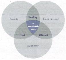
This representation attempts to graphically portray the
integrating nature of sustainability as opposed to the separate systems concept
of the traditional view of growth. Whereas traditional urban development ends
its consideration of economic growth at reinvestment and redevelopment,
ecological industrial design closes the loop by also considering restoration
and regeneration because it considers industry a natural system.
From
this perspective, business success and environmental health are two sides of
the development coin. As business succeeds, pollution and waste decrease. Eco-industrial development rethinks the
approach of exporting industries for a region that bring not only capital, but
also additional resources that circulate through the service sector.
It requires a customized approach for each locality within a region to identify
linkages among businesses, materials, energy resources, ecological systems and
local capacity. Consequently, there is
no set formula for eco-industrial development.
It's
hard to imagine what all this might mean. But consider the following
"design assignment" posed by William McDonough, one of the world's
leading ecological designers. He asks us to imagine designing a system
which:
- Puts billions of
pounds of highly toxic material into the air, water and soil every year.
- Measures prosperity
by the depletion of natural capital, resource materials and energy.
- Measures progress in
the number of smokestacks.
- Measures
productivity by how few people are working.
- Requires thousands
of complex regulations to keep people and natural systems from being
poisoned too quickly.
- Produces materials
so dangerous they will require thousands of future generations to maintain
constant vigilance.
McDonough
says that these are the retroactive design assignments of the First Industrial
Revolution. It's a frightening design problem, he adds, because these
assignments and values appear unethical.
But
now imagine being asked to design a system which:
- Releases no highly
toxic material into the air, water or soil.
- Measures prosperity
by how little capital is depleted and how much current income is accrued.
- Measures progress by
the number of workplaces emitting no harmful substances.
- Measures
productivity by how many people are working.
- Requires no
regulation or intergenerational vigilance because there is nothing there
to destroy anyone or any living system.
These
are the design assignments and values of the Second Industrial Revolution,
McDonough says. They represent opportunities for creative people and
institutions to create a better world.[1]
An identification of industrial sectors that top the lists of resource consumers, goods and services producers, and waste producers yields three principal sectors as a starting place for eco-industrial development focus. These are household goods production, construction, and sectors with significant environmental spillover effects such as chemical and municipal waste industries (Cohen-Rosenthal. 2003). These industrial producers must be examined relative to integration in three areas: transport of goods, production processes and maintenance processes. Co-location of industries (clustering) or networks of industries allows communication and leads to greater efficiency with fewer resources and less waste; alliances are created and innovation is encouraged.
Greater efficiency and environmental integration have other effects: instead of forcing subsidized or poorly designed products on the consumer under the guise of “green” technology, only demand driven production occurs. Eco-industrial businesses are more attuned to their community’s health if they’re integrated and supported locally. Employees are healthier and they are able develop a sense pride in their work and their community. Businesses invest more in their workers’ well being as productivity increases. The goal of sustainable family-wage employment grows closer to the reality.
As
John Tilman Lyle writes in his book Regenerative Design for Sustainable Development,
“regenerative technologies are relatively small in scale and suited to specific
applications under particular conditions. This contrasts with the large scale
standardized and more encompassing operations of industrial technologies…which
feature one way flows from producer to consumer and rely on a small number of
very large fossil-fuel power generating plants.”[2]
McDonough
and Lyle’s eco-industrial design principles have inspired our group to think
about how to apply his theory to Train Avenue’s industrial practices.
Traditionally, industries received inputs of raw materials such as coal or
electric power from a supplier in order to produce their goods and services.
The output of this process was then delivered through the transportation
systems – in the case of Train, it was historically through freight rail. The
external cost of this process is pollution, or waste from burning fossil fuels
in production.
By
contrast, we would apply the regenerative model espoused by Lyle and others to
an example in our study area – the paper recycling plant located at the
intersection of Train and Fulton. Recycling of paper fits with the
eco-industrial theme of reusing materials from the waste stream of another
industry as its raw materials. An eco-industrial model would seek to close the
loop, as to completely avoid waste and gain from the system’s natural
capitalism. One way we might do this is to rig a generator to the Norfolk
Southern train tracks connected to the Cleveland Public Power substation on
Walworth Avenue in order to capture the kinetic energy from trains lost while
braking (called regenerative braking, a
time-tested technology that isn’t used much [http://www.trainweb.org/railwaytechnical/tract-01.html#RegenerativeBraking
and http://www.railway-energy.org/tfee/index.php]
Therefore,
the train provides energy, raw materials, and the mode to transport the plant’s
recycled paper. Regenerative braking systems exist and if they need to be
customized for the situation at Walworth, the work can be done at the future
Ecological Industrial Design Institute (which we propose citing at the building
at Vega and Train).
On
more practical and immediate terms, the paper recycling plant could be
‘downstream’ from an operation such as a printing press that produces paper as
its waste byproduct. The paper waste from the printer can be carted to the
paper recycling plant (by upgrading the old rail spur at Vega and Train) on
self-propelled diesel train cars from one end of Walworth Run to the other.
“Self-propelled diesel makes freight trains more truck-like, i.e. replace(s) long loco-hauled
trains by smaller units with a high degree of modularity and flexibility,”
according to International Union of Railways.
To
further enhance the eco-industrial model of Train Avenue, our group proposes
acquiring the property at the corner of W. 30th and Train, which is
currently occupied by an auto impound yard. Historic plat maps show that a
wetland once existed on that property (which may help account for the flooding
that occurs in this spot during heavy rains). The plan would be to remediate
the leaking motor oils and acids that have presumably leached into the soil
using an environmentally sound in-situ process such as natural bacteria,
electrical separation or phytoremediation [www.epa.gov/tio/download/remed/electro.pdf].
Thus,
the site in the short term becomes an eco-educational opportunity for the
proposed new high school located just west, and a green space/rest stop along
the Towpath connector’s route. After the bioremediation is complete, the
long-term plan would be to convert part of the plot into a bioswale or
constructed wetland that could be used as a stormwater recharge basin. Once
again, Lyle explains the rationale. “Regenerative waste management works best
on the local scale.
Managing
storm water in regenerative ways usually means retaining it near where the rain
falls, which requires reshaping the landscape in ways that can be readily seen.
When form facilitates
flow, it is part of the landscape where we see it. The forms of regenerative
technology impart useful information and increase our understanding of the
world.[3]
Of
course, this idea is being carried forth in the planning or the Cuyahoga Valley
Initiative. The initiative’s ‘idea packet’ on the economy speaks directly to
this idea of regenerative economies:
While the images most associated with the
Cuyahoga Valley are of gigantic lake carriers and steel mills, it also is a
center for finance, new economy services, entertainment, and environmental renewal.
With these assets and more, we possess the potential for making the Valley the
center for an economy based on regeneration.
The
group also proposes to tie the development of green technologies to the area by
housing the Institute of Ecological Design on the upper floors of a building
located adjacent to the paper recycling plant – on the corner of Vega and
Train. This building is currently owned by Downing Enterprises, a sign
manufacturer. Considering the market value (as determined by the Cuyahoga County
Auditor’s office) of $283,000 we have determined that it is not economically
feasible to purchase the building outright. Instead, we propose to occupy part
of the 45,000 sq. ft. building through a lease-purchase program. According to The Association for
Governmental Leasing & Finance, a tax-exempt lease or lease-purchase
agreement is an installment purchase, conditional sale or lease with an option
to purchase for nominal value. It may also be referred to as a municipal lease.
Educational nonprofit organizations do qualify as lessees in government
lease-purchase
programs. Tax-exempt leases are structured as a series of
one-year renewable obligations that are subject to the governmental entity’s
ability to appropriate funds for the continuation of lease payments. Payments
constitute a current expense of the lessee and, in the event that sufficient
funds are not available for payment, the agreement is terminated. The term of
the lease may not exceed 120% of the average reasonable expected economic useful
life of the property or project being financed.
Based
on those terms and conditions and the net lease rates for nonprofit
organizations on the near West side of Cleveland, the Ecological Design
Institute should rent space at no more than $10 sq. /ft. for white box office
specs (based on Triple Net rents per sq/ft paid by nonprofits at the Cleveland
Environmental Center), and probably $6 sq/ft. for unimproved space.
Applying
Eco-Industrial concept to Walworth Run & Train Avenue
The
key to creating an eco-industrial system within the corridor is to recognize
and build from the current and future assets, and to be conscious of the
barriers both geographic and economic (at least in the short run). To develop
an eco-industrial corridor, planners of large-scale development such as the
future industrial park at W. 65th and Train (the WIRE-Net site)
should be engaged in a conversation about the types and uses of the industries
that settle there. Not to demand that WIRE-Net (or whomever the developer is)
needs to limit themselves to any one particular type or use, but,
when considering the highest and best use and aspects of Walworth Run such as
proximity to redeveloping markets, opportunities to facilitate an
eco-industrial concept should be part of the planning framework. In other
words, there needs to be a plan and perhaps some incentives that are used to
push traditional industrial operations to participate in an eco-industrial
loop. For instance, if a manufacturer of street furniture made from recycled
plastic locates at the WIRE-Net park, they would receive a guide to
eco-industrial concepts and opportunities such as capturing and reusing their
waste water and exporting their waste products.
By
contrast, a ‘pull’ strategy would be to proactively identify an existing
condition and try to attract an operation that benefits from the eco-industrial
systems thinking. For example, the city of Cleveland expects to demolish a
number of condemned houses in the area adjacent to Train in the next few years.
One eco-industrial proposal to consider is locating a construction/demolition
operation on Train Avenue. It could serve the dual purpose of temporary storage
and sorting building materials for recycling as well as offering a legal
operation and, thus, a solution to the illegal dumping of
construction/demolition waste that continues unabated on Train Ave. In
addition, we could partner with the Cuyahoga County Solid Waste District to
simply provide a paper-recycling bin through its Paper Retriever Program (http://www.cuyahogaswd.org/residential/retriever.shtml
) for use by the public which we can locate in front of the paper recycling
operation at Fulton and Train. The paper recycling plant gains from the inputs
of the public’s waste and from not having it littered on its address and the
proceeds from the program benefit a local organization.
This
concept of making legal and more visible the recycling of ‘waste’ into usable
inputs for another industry can be a branding opportunity, which is
carried throughout the corridor. Walworth Run can be the city’s Re-Cycle
Corridor – an area that serves as a pilot for a closed-loop industrial
district and where you can cycle up from the Towpath to observe an eco-industrial
operation.
Integrating
Walworth Eco-Industrial and the Cuyahoga Valley Initiative
1. Use a watershed approach to emphasize the Walworth Run as a tributary of the Cuyahoga (per CVI Community Capacity package, p 5; Design package, p 4; Healthy Valley package, p 3); adopt a comprehensive, regenerative, sustainable development strategy under a Cuyahoga Valley Redevelopment Authority as lead agency responsible for coordinating all systems in the watershed (per CVI Business Innovation package, p 7). Identify the key issue areas for such an authority and assign responsibilities to member jurisdictions and agencies based on expertise or capability (per CVI Community Capacity package, p 5).
2. Research the economic potential of and business support level for a special improvement district (e.g., a business revitalization district, neighborhood conservation area, empowerment zone, etc.). Survey business groups to undertake a comprehensive inventory of existing businesses, their outputs, and their requirements; develop recommendations for a workforce development program for residents; promote a local partnership committee including business, councilpersons, city, county, state departments/agencies, CDC’s & ED’s (e.g., Clark-Metro, WIRE-Net), residents, etc. (See 1 above.). This approach would allow mobilization of local assets and the formation of partnerships to leverage those assets to support reinvestment.
3. Approach ODOT about using W 65th & Train Ave as a temporary commuter corridor for I-71 traffic during the Innerbelt renovation project, with W 44th & Lorain as the temporary corridor for I-90 traffic. Such an approach could introduce the area to more people, supply additional funds for the immediate repair of Train Ave, lend greater immediacy to and funding for repairs for the Fulton Rd and Eagle Ave bridges, and allow for a “trail” on a wide shoulder to encourage bicycle commuters and provide a connection to the Towpath Trail. These near term outcomes could be instrumental in developing support to ultimately “daylight” or recreate the Walworth Run as an urban stream and boulevard project (see 2 above).
4. Expand the Eco City Cleveland Lakefront rail bypass study to examine the long-term possibility of re-routing the main rail corridors around Cleveland, with spurs serving rail customers in the City instead of main lines.
5. Implement eco-industrial overlay zoning to counter the detrimental effects of single land use classifications (e.g., prohibit heavy industry in area due to land availability while promoting light industrial/manufacturing uses compatible w/ residential & retail uses) (per CVI Healthy Valley package, p 6 and the); brand the area as the “NEO Eco-Industrial PARKway” or The Re-Cycle Corridor; encourage physical connections to draw from a greater geographic area.
6. Ecological-Industrial Design Institute (per CVI Design package, p 7) to incorporate sustainable environmental strategies (see 7-13 below) with urban geography/econometric models; could promote high school level programs for community education w/ proposed new high school (e.g., Independence Schools’ “Land Lab” concept referenced in CVI Community Capacity package, p 4).
7. Brownfield cleanup, land acquisition programs
8. Bio-med research and/or manufacturing (per CVI Business Innovation package, p 3)
9. Adaptive reuse where feasible (maintenance instead of new construction); green building codes with LEEDS certification requirements.
10. Construction/demolition recycling in addition to paper recycling (“Architectural Salvage Program” per CVI Business Innovation package, p 4).
11. “The Sun Shines on Train”: use solar energy, or fuel cell technology along the rail corridor as a development draw; or, use geothermal energy if possible for demonstration projects.
12. Greenhouse industry: a “greenhouse alley” (in Vega-Barber area) with clean, green, & compatible uses as part of a regional-based food system& native-species plant nursery (per CVI Business Innovation package, p 4).
13. Environmental restoration programs including slope stabilization, constructed wetlands, infiltration and storm water recharge sites.
An Eco-industrial example for the Train Ave:
Bringing back a Brewery
The near west side was known for its breweries among
other industries. Many residents recall
these breweries from their childhood memories.
If feasible, this would be a nice element to reintroduce to the Train
Avenue/Walworth Run Corridor, provided that it is green-friendly.
An eco-friendly
brewery/learning center/museum/pub would benefit the local economy and help to
create a new anchor for the region. Two
breweries that have initiated a “zero waste” policy include the local Great
Lakes Brewery and the not-so-local Namibia Brewery in Africa. Both breweries promote research and
integrate environmentally sound processes into their everyday activities.
These examples
should be studied to see if they could be reproduced at the Train
Avenue/Walworth Run Corridor. Even if
only a portion of the brewing process occurs at this site, it would still
promote historical and economic value.
Ideally, the
brewery should promote active learning, by developing an
indoor/outdoor laboratory that shows the entire process of creating beer—from
growing hops to capping bottles. The
brewery could also display its environmental practices that relate to its ‘zero
emissions’ goal. The process could also
be tied into the daylighted portion of Walworth Run if applicable.
This industry
would be compatible with housing, and thus be a perfect infill project for the
Queen/Barber area. It would capitalize
on location—being near various forms of transportation, not to mention being a
tourist attraction within the Cleveland limits.
Below are some
highlights regarding the Great Lakes Brewery and the Brewery in Namibia:
Great
Lake Brewing Company
"While
we're strong proponents of operating a manufacturing enterprise that is
environmentally friendly, we also realize that it has to make financial
sense," In the process of seeking
ways to make our operations more environmentally friendly, we've been able to
cut operating costs at the same time. It's simply a matter of taking the time
and making the commitment up front to explore the technology that's out there,
and find a way to do it that makes environmental, financial and social sense -
what we refer to as a triple bottom line."
Since our founding, the Great Lakes Brewing Co. has maintained a commitment to
operate in an environmentally responsible manner. In 2001, we launched our Zero
Waste Initiative to minimize energy and resource use and maximize materials reuse.
Our ultimate goal is to mimic nature, where 100% of resources are used in
closed-loop ecosystems. Nature generates zero waste.
The health of Northeast Ohio's waterways is of particular
concern since our beer is over 90 percent water. Conventional food production
generates huge amounts of chemical pesticides and fertilizers which drain into
and pollute our waterways. Moving toward local and organically-grown products
is one way we can minimize the environmental impact of our own activities,
while at the same time enhancing the quality and taste of our food and
supporting local businesses.
The Zero Emissions Brewery, Namibia, Africa
An
interesting example of eco-industrial development is the Zero Emissions Brewery
in Namibia, developed by the United Nations Zero Emissions Research Initiative.
This project integrates a brewery, an aquaculture facility, and an agriculture
system in a rural area to produce beer, food, clean water, and jobs. (The
proposed brewery would be on a much smaller scale, but with the same
principals.)
Use Less Resources and Energy
- Methane from an on-site bio-digester is used as energy
source.
- Biodiversity of fish species, instead of machines is used to
aerate water in fish ponds.
·
Use Resources and Energy Efficiently
- Brewery waste-water is used to wash pig pens.
- Fish ponds are used for growing hydroponic crops.
·
Re-circulate Resources
- Sewage and other wastes are fed to bio-digester to produce
methane.
- Mineralized water from the fish ponds used to irrigate and
fertilize fields.
- Spent grains from brewery are used as growth medium
for edible mushrooms, for earthworm production, and as feed for livestock.
- Spoilt brew returned from market is fed to the bio-digester
and its’ packaging is fed to livestock.
Eco-Industrial
Resources
a. The Journal
of Industrial Ecology
http://mitpress.mit.edu/journal-contents.tcl?issn=10881980
Selected articles, forums, reviews, predominantly in industrial metabolism and
materials flows analysis so far.
b. The Center of
Excellence for Sustainable Development http://www.sustainable.doe.gov
Sustainable community, industrial ecology, and eco-industrial park information,
including articles and bibliographies. Maintained by the Department of Energy.
http://web.mit.edu/org/c/ctpid/www/tbe/
John
Ehrenfeld's program at MIT includes an extensive IE and design for environment
bibliography, abstracts of some papers and copies of his papers.
d. Zero
Emissions Research Initiative
e. ECO-it
http://www.pre.nl/eco-it/default.htm
Design
for Environment software. Based on the Eco-indicator method, ECO-it helps
designers to screen products for environmental improvements by allowing you to
model a complex product and its life cycle in a few minutes.
f. Rocky
Mountain Institute http://www.rmi.org/ has
been applying systems thinking to energy and transportation issues for over two
decades, including the Hypercar concept for very high efficiency vehicles. In
the 1990s, RMI has added valuable work in community and real estate development.
g. McDonough
Braungart Design Chemistry http://www.mbdc.com
h. Interface,
Inc.'s "Journey to Sustainability by Practicing Industrial Ecology. We
accept our responsibility as a member of the industrial world... if we can get
it right (recycling), we might never have to take another drop of oil from the
earth."
Resources
for Trails projects
The
Federal ISTEA bill has a program called the Symms National Recreation Trails
Program
Also,
NOACA disbursed CMAQ (Congestion Mitigation and Air Quality Improvement
Program) Funds which can be used for bike or multi-use paths.
IV. Connections
Thematic
Connections
Connection /kәnékshәn/ n. 1 link
2 meeting point
–
Synonyms: linkage, bond, link, association, relevance
Connections
improve quality of life by providing access to area attractions, a better
environment, and recreation, amongst others.
The main connection between the destinations within the Train
Avenue/Walworth Run area and the local region will be the proposed road and
contiguous multi-use trail. This
road/trail proposal will create a commonality in which all people will enjoy
the corridor. By infusing a park-like
setting into the corridor, the impact of having numerous types of transit-users
commingling will be softened while simultaneously strengthening the union of
the mixes.
Neighborhood
connections are essential for the proposed multi-use corridor to be
successful. The main neighborhood
connections for the central portion of the corridor are located at W25th (the
Scenic By-way), W30th, Fulton (via Vega Ave.), Roberto Clemente Park, Richner
(at W41th) and W44th. Another
essential—and easily attainable link includes connection to the Towpath
Trail.
Destinations
that are nearby and easily accessible via the Train Avenue/Walworth Run
Corridor, include the Cuyahoga River, Interstate 90, the ‘Antique’ district on
Lorain, The commercial district on Clark Ave., Eco Village, Ohio City Historic
District, the Flats and Tremont. Other
local sites with historic meaning can also be destinations for those traveling
the Corridor, local churches for example.
The
creation of a park setting will prove to be a valuable anchor, creating a
relationship between local transportation modes, local and historical
destinations, neighborhood residents and local communities. It will also tie in nicely with the Cuyahoga
Valley Vision Statement.
The
Cuyahoga River Valley will become a recreation and leisure activity focal point
through a series of experiences which embody the Valley's cultural, historical
and ecological significance. By creating a significant tourist attraction rich
in natural resources, the destination-center focus for the Valley will spur
economic growth for the region. www.cuyahogavalley.net
Proposed Connections
There is presently an extension of the Towpath Trail
proposed to reach up into the Cleveland Flats and along the banks of the
Cuyahoga River. What was once part of the natural watershed of the Cuyahoga
River, Walworth Run, has been buried under Train Avenue for about the past one
hundred years. Walworth Run no longer sees the light of day until it dumps into
the Cuyahoga through a pipe along its western bank. The forgotten valley carved
by Walworth Run has been a dumping ground for peoples refuse for decades, but
has the potential to be an asset to the community. By taking advantage of the
natural landscape, Train Avenue, or “Walworth Run” can be a vital part of the
urban fabric. By making connections to the neighborhoods from the valley, the
area could be an ideal setting for a multi-purpose trail for neighborhood
residents and travelers along the Towpath Trail. People taking the quickest and easiest route to their desired
destinations have already created many of the connections being proposed.
Others require a little more imagination and development to be successful.
Nonetheless, a Walworth Run extension has the potential to be a catalyst of
positive change to the entire area.
The neighborhoods surrounding Train Avenue are rich
in history with homes dating back over a century. Many could be restored to
their former glory with a little hard work and money. These types of changes
have been occurring throughout the near west side for over the past twenty
years, but not much activity of that type has been going on in the
neighborhoods south of Train Avenue. A recreational amenity such as the Walworth
Run Trail with connections to the neighborhoods can provide the impetus for
renewal in these areas as well.
West 30th and Train Avenue
Along
the proposed Walworth Run Trail, there are several connection opportunities
between West 25th and West 44th Street. Heading west from W.25th Street,
the first is at the southeast side of the West 30th and Train
intersection.
A
trail can be cleared that starts at the base of the intersection and can run up
the gently sloping hill to the base of the proposed new development at the
former foundry site and could merge into Swift Road and connect with the Ohio
Canal Scenic Byway [West 25th Street]. This connection can be easily
attained by clearing some overgrown brush and laying a trail along the northern
edge of the foundry site and would provide spectacular views of downtown
Cleveland. It would also help connect the neighborhood to the Walworth Run
extension and travelers along the Ohio Canal Scenic Byway.
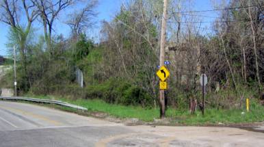
Southeast corner of Train and
W.30th
Roberto Clemente Park to Train
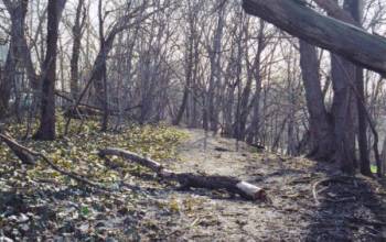
Natural trail along the left field
side of Roberto Clemente Park
Coming
out of the left field corner of Roberto Clemente Park, just to the south of
Train Avenue, is a trail that has been formed by years of foot traffic. This is
a natural location for a connection to the proposed Walworth Run extension. The
proposed connection will extend down to the south side of Train Avenue through
an overgrown area. This would be an ideal place to relax along the Walworth Run
Trail or for people in the neighborhood to get onto the Trail. The historic
path of Walworth Run runs directly to the south of Train and would be an ideal
location to daylight the stream for a stretch. The neighborhood surrounding
Roberto Clemente Park is densely populated; the park is frequently used for
baseball and neighborhood children use the playground regularly. This
connection could open up the Walworth Run Trail to a large number of people and
is a natural place to connect into the neighborhood.
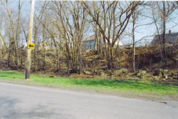
Potential site for a place to relax
along Train
This
area lies just to the east of the intersection of Richner and Train and just
west of Roberto Clemente Park. The informal trail formed by people using
Roberto Clemente Park can be extended to this area. It is overgrown but has a
great deal of potential as a place to stop along Walworth Trail and relax. If
Walworth Run could be daylighted, people could get a glimpse of how the area
looked over a century ago and foster a greater sense of the natural environment
that once existed in the areas history.

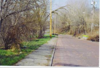
Park-like setting with brick road
exposed along Train
Daylighting
Walworth Run can also help with flooding issues, which occur due to heavy
rains. A cobblestone roadway would also help by allowing water to seep into the
ground, while a paved road will cause rain runoff to pour down into the sewage
system quickly, which often causes the rain runoff to mix with the sewer lines,
and drain directly into the Cuyahoga River. By creating a more natural space,
the ground will act as a sponge and soak up a lot of what often goes straight
into the storm water system.
Richner Avenue to Train
Richner looking northeast to Train
The
intersection of Richner Avenue and West 41st may be home to a new
school. This makes Richner an integral connection point to the neighborhood.
Students can use the Walworth Run extension for recreation, and the
neighborhood itself can use the proposed connection to travel to the Towpath or
simply take a leisurely stroll. West 41st also connects to the north
side of the neighborhood, and can provide easy access for them to take
advantage of the new Walworth Run Trail.
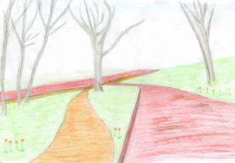
Potential look of Richner
connection to Train
West 44th and Train
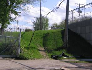
Southeast corner, West 44th and
Train
As
one can see, there is already a path being created by the foot and bicycle
traffic that already occurs by people going to and from Train Avenue. This
would be an ideal location for a set of stairs or a gentling sloping trail for
people to get quick access to Train Avenue.
Underneath
the pot-holed surface of Train Avenue are the original cobblestones. Many
neighborhoods in Cleveland, and roads merging into Train, still retain this
attractive finish. Taking the road back down to the original appearance can be
advantageous for several reasons. One, speeding has been an issue for years
along Train Avenue for years- the cobblestones slow down traffic considerably
because the ride is not as smooth as a paved surface. A cobblestone
road is also more in keeping with the historic character of the area and is
already there beneath the dilapidated asphalt.
Taking
the road back down to its original surface would not be an outrageous expense.
According to Allega Construction, Inc., of Cleveland,
Ohio, the three mile length of Train Avenue can be scraped down to cobblestone
and hauled away for roughly $150,000. Of course, the cobblestones are going to
be in need of some repairs as well. The total cost of repairs to Train Avenue
should be in the range of $225,000. Not only would this improve the overall
appearance of Train Avenue, but would allow more of the rain runoff to soak
into the ground instead of flooding the sewer system and causing the sewer to
back up, thus flooding the road.
Many
of the proposed connections are already being made due to necessity, but can
easily and affordably be improved upon. Others require a little work, but there
is no need for heavy construction to connect the neighborhood to the Walworth
Run Trail. A Walworth Run Trail can become a great asset to the community.
Train Avenue is already being used by cyclists and joggers, but in its present
condition is not safe or inviting. By creating the connections into the
neighborhoods, people will have a much-needed place for recreation but a reason
for others to explore what the area has to offer and hopefully spur new
development. The neglected Walworth Run Valley can become a vital part of the
neighborhood and a place for recreation.
V. Daylighting and Constructed Wetland
Concept
While
the Valley will never revert back to its original natural condition before
industrial development took place, it is still possible to support
biodiversity, shape the built environment, and re-establish natural systems in
such a way that prevents further degradation of the watershed, waterways, and
slopes that characterize the Valley and enhances the Valley's ecology (www.cuyahogavalley.net).
Restoration of a natural system is a unique way to spark interest in the
redevelopment and strengthening of an urban neighborhood.
Train
Avenue roughly follows the former path of Walworth Run and faces flooding
issues during periods of heavy rains. Walworth Run, a headwater stream of the
Cuyahoga, is currently culverted and utilized as a sewer. Headwater streams are the small network of
streams that are generally less than one square mile and provide benefits to
the larger river system they are connected to. These benefits as documented by
Ohio EPA include; sediment control, nutrient control, flood control, wildlife
habitat corridors and water and food supply to nourish downstream segments with
organisms. (http://urban.csuohio.edu/academics/graduate/mupdd/mupdd_capstone/team_a/teama_mid_report.htm)
The
stream was buried over a century ago and the sewer system, which was created at
that time, is overdue for renovation. The cost to excavate and repair could be
in the millions to ameliorate the problems currently facing Train Avenue. In
the present situation, sewage and rainwater often combines and flows directly
into the Cuyahoga River. Daylighting the stream can be less expensive than
devising two separate sewage lines to separate the runoff.
Daylighting
Walworth Run could possibly pose a challenge due to the fact that it is a
combined sewage overflow system rather than merely a runoff sewer; depending
upon how the culvert is actually created.
In addition to the physical challenges posed, the upfront costs for
daylighting can seem overwhelming, but many such projects have been mitigated
through community support, donations and volunteerism.
If
done properly, a restored stream can handle much of the non-point source
pollution storm sewers direct to it. In
the case of combined sewer outlets (CSO’s), a restored stream with significant
riparian areas can absorb and help clean much of the wastes before they wind up
in the rivers and lakes. “Soil and
vegetation can also filter, transform, bind up, or otherwise neutralize much of
the pollutants found in urban storm water runoff.” (http://urban.csuohio.edu/academics/graduate/mupdd/mupdd_capstone/team_a/teama_mid_report.htm)
This picture is of the River Wey,
which flows through the Bass Brewers site in Alton. This river has been recently daylighted on the brewery’s
property.
Benefits
- Relieve choke points
and flooding problems caused by under-capacity culverts
- Increase hydraulic
capacity over that provided by a culvert, by recreating a
floodplain
- Reduce
runoff velocities—thus helping prevent erosion
- Replace deteriorating
culverts with an open drainage system that can be more easily monitored
and repaired
- Cost less, or only
marginally more, than replacing a culvert
·
Divert urban runoff from combined sewer
systems before it mixes with sewage, reducing combined sewer overflows and
burdens on treatment plants
- Improve water quality
by exposing water to air, sunlight, vegetation, and soil, all of which
help transform, bind up, or otherwise neutralize pollutants
- Re-create aquatic
habitat and improve fish passage (if any currently exists)
- Re-create valuable
riparian habitat and corridors for wildlife movement
- Provide recreational
amenities, such as a streamside bench for people to relax upon
- Create or link urban
greenways and paths for pedestrians and bicyclists
- Serve as an
"outdoor laboratory” for local schools
- Beautify
neighborhoods, perhaps serving as a focal point of a new park or
neighborhood revitalization
project
- Increase property
values
- Build civic spirit
and relationships as local residents, businesses, and governments come
together to create the project
- Reconnect people to
nature through the look, feel, and smell of open water and riparian
vegetation, and through contact with aquatic and streamside creatures
- Give people a sense of
“setting right something we messed up.”
There is tremendous desire in many communities to make the
most of their environmental assets. Restoring a stream that was lost gets a lot
of attention and there is a lot of desire to do that. The stream can also act as a catalyst of renewal for
the surrounding area and a source of pride for the community.
There is also the impact that water has on us emotionally and
psychologically. Often the more urban a project is the more significant that it
is. People are drawn to a place where they can hear moving water.
Problems
While
there are numerous benefits from daylighting streams, there are concerns as
well. Experts in this field should be
involved from the outset to ensure the feasibility of the project and to direct
all aspects, including technical, political and community involvement.
Surface
stream restorations are sometimes politically easier because the problems are
apparent or easily pointed out. With buried waterways, people may be unaware
that a culvert carrying a historic stream is under their feet, or that the
stream’s absence means degraded water quality, lost habitat, and so on.
Since
there’s “nothing” there now, daylighting projects may require extra community
education and outreach to help people visualize the potential. Moreover,
creating an open channel often raises fears: kids will fall in and drown, pests
will proliferate, the channel will flood, and adjacent property owners will
face additional environmental regulations. Addressing these concerns is often a
big task for daylighting proponents. At the same time, daylighting projects can
generate a level of excitement.
The
above bullet points as well as several examples of success stories can be found
at the Rocky Mountain Institute’s website at: http://www.rmi.org/images/other/Water/W00-32_Daylighting.pdf.
This
link is another great place to start a search regarding daylighting streams and
rivers:
http://webpub.alleg.edu/employee/e/epallant/coursehome/JrSem%20Mill%20Run/Mill%20Run%20Links.htm
Re-creating a Wetland at W.30th and Train
Avenue
Evidence
of scrub/shrub wetlands is found in the study area. This would be expected because of Walworth Run. It would seem logical to study the benefits
of re-creating or salvaging natural wetlands in the area. The main focus for the central portion of
Walworth/Train Avenue would be the wetland near W 30th Street—the
site of the former Mill Pond.
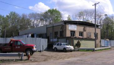
West 30th and Train
A&M Towing sits at the southwest corner of Train Avenue and West 30th
Street. The site occupies 84,070 square feet above the historic path of Walworth
Run. As one can see, the surface of the lot is dirt, with little vegetation to
absorb rain runoff. By creating a wetland, or bog, flooding can be prevented
because rain runoff will collect from further up Train Avenue and from the
southern rim of the Walworth Run Valley at W 30th St.
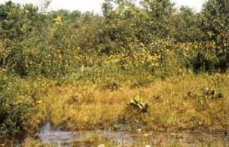
Birds
would make this a stop over place on their annual migrations. Native trees can
be reintroduced to the area, such as beech, sugar maples, buckeyes, tulip,
white ash as well as many other varieties. Indigenous vegetation such as slough
grass, Spanish needles, peppermint, cinquefoil, Russian thistle and fall panic
grass would comprise the undergrowth, and be able to handle the harsh Cleveland
winters. This not only makes environmental sense but also would create a reason
for travelers along the Towpath Trail to head west along the Walworth Run
Trail.
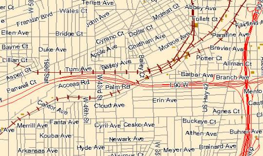
Map of wetlands in area—dark
spots indicate wetlands. Cuyahoga
Planning Commission Brownfields GIS website.
VI.
Designing the Re-Cycle Corridor
Lessons
Learned from Phase One
During
Phase One of the project community involvement was sought from local residents
and business owners. Several key issues
emerged from these community meetings related to the design of Train Avenue. Both groups, residents and business owners
alike, stated that Train Avenue is a dirty, dangerous place. Business owners often felt the repercussions
of illegal dumping on and around their property. Residents said that Train Avenue is a known place to dump what
you do not want. Typically dumping
sites are the vacant or abandoned properties.
The condition of the road was also sited as a major impediment to the
success of the corridor. Property
owners often have drainage issues as a result of on-going sewer problems. Lighting is also a problem; there is not
enough lighting, especially under the bridges, which makes it feel even more
dangerous than the general emptiness within the corridor. Lastly, speeding on the road has been a
problem in the past, but the deplorable road conditions have reduced this
problem.
Positive
information and sentiments also arose from the community meetings. For example, many of the residents remember
the breweries that were located on Train Avenue and have fond memories of
watching the bottling machines from the outside. Beyond good memories is the reality that many viable businesses
are located on Train Avenue; many of which have long histories in the
area. Lastly, both community groups
reacted favorably to the notion of
extending the towpath trail along Train Avenue. They viewed it as a way to make the area safer by bringing people
there.
As a result of the community input, several
necessary design improvements are recommended, including:
- Install proper
lighting
- Improve the road
conditions and correct the sewer problems
- Take preventative
measures to reduce the ability to dump on occupied and unoccupied
properties
- Develop vacant
properties
- Landscape the edges
of the road
- Create a multi-use
trail
- Explore traffic
calming options before road improvements are made
These
recommendations are the minimum design related issues that should be
addressed. A discussion of recommended
amenities follows.
Design
considerations set forth for the Re-Cycle Corridor were influenced by the
Cuyahoga Valley Initiative’s six idea packages. In addition, the sample images provided are implemented in other
cities throughout the world. The key to
a successful environment such as that proposed is high quality, consistent
branding. Branding can be done in a
multitude of ways, but for this discussion, the focus is on place.
Signage
Signage is the most significant implementation tool for branding a place such as the Re-Cycle Corridor. Signage serves to provide information on a variety of levels. Signage is most commonly used for safety purposes, to give some type of instruction or warning. The Re-Cycle Corridor will take this purpose to the next level by provided information ranging from way finding to telling the corridor’s history. Way finding (see Photo 1) will be critical to the success of the corridor because it will thrive through its connections to the neighborhoods and community assets.
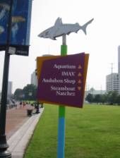
Photo 1:
Way-Finding, New Orleans
Creating
amenities through signage is also a very popular way to draw people to a place
because more meaning is given to it that is often not obvious. For example, in Baltimore, Maryland, a
fountain-like bubbling in a river is described on an easy to read and
understand sign that reveals its truth – it is an environmental remediation
project.
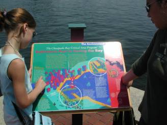
Photo 2:
Signage - Environment Education, Baltimore
An historic marker is another way to bring meaning
to a place beyond its current condition.
See Photo 3, a sign describing a maritime event in New Orleans.
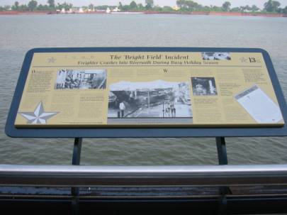
Photo 3:
A Snapshot of History, New Orleans
Another
much appreciated type of signage is that which informs you of what you have
accomplished especially if you are using the trail for health and fitness
purposes. For example, Photo 4
demonstrates a mile marker in Chicago.
Other examples of signs that are similar in nature include fitness stops
where exercises or stretches are recommended or simply reminders such as
checking your pulse rate for your target heart rate to maximize your workout.
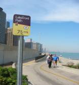
Photo 4:
Trail Mile Marker, Chicago
Signage
in the Re-Cycle Corridor should be coordinated by a professional with local
input and final approval. Signage is a
primary branding tool that should be done well. Adequate funding should be secured for this portion of the trail
design because it can truly affect how user friendly the environment is, thus
impacting the overall success of the trail.
In addition, a comprehensive signage package also provides the
opportunity to create spill over effects by supporting other agendas. For example, in the Re-Cycle Corridor, the
way-finding system could lead trail visitors into the neighborhood business
districts, which could increase their revenues.
Implementing the Vision
The
vision for the Re-Cycle Corridor is that it connects industrial uses and
renewable resources as well as integrating new land uses and development
opportunities. The goal of the corridor
is to support a healthy valley and to invite people to experience a place of
innovation where nature and industry converge.
As such, the vision should be carried forth through the overall design
by way of sustainable materials; where possible, recycled products should be
used. For example, the trail material
could be a recycled glass product that is available through Andela Products (www.andelaproducts.com/products). The Andela glass pulverizer creates a safe
glass material with no sharp edges that can be adapted for a variety of uses
and is often used for parking lots. By
using a product such as this, not only is it recycling, but it is also
harkening to the brewery history on Train Avenue where beer was bottled in the
Leisy Brewery.
Further,
the materials used within the corridor must be enduring such that it can resist
weather conditions, high volume use and the occasional vandal. While Train Avenue is currently a fairly
deserted place that allows for vandalism to occur often, the Re-Cycle Corridor
will be a catalyst for change in this area.
By bringing more activity to the area, it will inherently improve, but
design will also impact how successful the area is with regard to safety
measures on the whole. Examples of
enduring, yet still green, include recycled plastic outdoor furniture and trash
bins that are available through multiple distributors including Belson Outdoors
(www.belson.com).
Suggestions
such as those described thus far are general conversation starters that could
be discussed during the community involvement process of the overall plan. These suggestions assume that the theme for
the corridor has been accepted based on the community involvement received
during Phase One. However, if starting
from scratch, the overall approach to the corridor should be a community
conversation through a similar discovery process as demonstrated by the Phase
One community meetings.
Community
involvement should be central to the decision making process particularly as it
pertains to gaining insight into neighborhood dynamics, trail user amenities,
partnering with local and national organizations and identifying
resources. A common way to do begin the
community involvement process is to identify stakeholders to form a steering
committee. It is important to create an
exhaustive list of stakeholders even though many may not be participants in the
steering committee, they could be resources in the future. Through steering committee, community
meetings can be held to capture a larger cross section of viewpoints and
generally get a pulse on the community (www.rachel.org). The more quality community involvement that
can be applied to the project the better because it will create a larger sense
of ownership, which will bring a greater chance of success to the final product
once it is operational.
Establishing
and leveraging ownership on a product such as the Re-Cycle Corridor will be
essential to every aspect from initial idea generation to implementation
strategies, particularly in the area of funding. Partnerships should be sought to maximize the trail’s potential,
but also to celebrate the wealth of community assets throughout the city. Making connections to organizations that may
not be in the immediate area is worthwhile in this regard. For example, the multitude of cultural
institutions at University Circle, like the Cleveland Botanical Garden and
Natural History Museum, could offer significant contributions inherently
through their established missions that will “cross the river” and possibly
reach new audiences. In addition,
resources could be brought to the table in this fashion that would simply
improve the entire project.
Amenity Options
Making
the Re-Cycle Corridor the best it can be can be achieved through the addition
of amenities. Amenities make a
statement about place and ultimately translate the goals of the project into
tangible realities for those experiencing that environment. For example, through the creation of “Relaxation
Zones,” people will be drawn to the area, which will support the community’s
desire to make the place safer (see Photo 5).
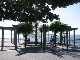
Photo 5:
Relaxation Zone, New York City
Relaxation
zones are areas where people passing through the corridor can take a break to
get a drink of water, take in the view, and enjoy a picnic. The degree to which these relaxation zones
are carried out is ultimately a funding issue, but this is one example of how
community involvement can be utilized in a creative way. Stakeholders can construct their own idea of
what a “relaxation zone” is and then work through its potential within the
project scope as a team.
Community
involvement during the design of the trail could be really rewarding and
produce amazing results. For example,
community groups could sponsor public art along the corridor. If train noise is a problem and noise
buffers are required, sound barrier walls could be installed with the
expectation that the walls will don murals (see Photo 6).
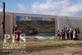
Photo 6:
Sound Barrier Wall, Vicksburg
Local
artists (Cleveland Institute of Art students, Cleveland School of the Arts
students, Art House participants, etc.) could work with the groups to produce
wherever the imaginations flow. The
transit authority in Seattle, Washington has had great success with a similar
program for transit station stops. This
approach could also been applied to the underbellies of the numerous bridges in
the corridor. See Photo 7.
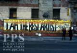
Photo 7:
Graffiti Wall, New York City
The
bridges within the corridor are many and often very interesting
architecturally. Such bridges could be
lit for drama like the Detroit Superior Bridge in Cleveland is (see Photo 8). This would also serve as a safety
demonstration.
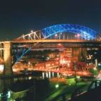
Photo 8:
Detroit Superior Bridge, Cleveland
Lighting
in general is an opportunity to fulfill two missions: safety at night and
creative functionality. To further the
sustainable theme of the Re-Cycle Corridor, lighting could be generated using
an alternative energy source. See
Photos 9 and 10 for two excellent examples of lighting as art.
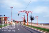
Photo 9:
Street Lighting, Spain
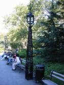
Photo 10:
Pedestrian Lighting, Location Unknown
One
element of place making is through the inclusion of public art. For the Re-Cycle Corridor, it is recommended
that the art should incorporate sustainable principles and again, further the
goals of the overall project. Photos 11
and 12 demonstrate that functionality and art can co-exist. In addition, Photo 11 is an example of a
durable product.
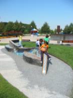
Photo 11:
Playground Seating, Chicago
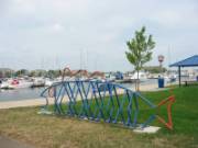
Photo 12:
Artful Bike Rack, Location Unknown
Art
also sends a message; it can educate and inform. A way in which this can occur on Train Avenue is through the use
of a symbol, such as that depicted in Photo 13, to identify what cannot be
seen. A symbol could be embedded in the
ground to show the location and direction of the flow of the original Walworth
Run stream. Such an exercise could
inspire people to think about land use and how human development impacts
nature; further supporting the goals of the Re-Cycle Corridor.

Photo 13:
Example of Symbolism, Toronto
A
celebration of what the Re-Cycle Corridor is will resonate throughout with the
selection of meaning public art and signage, but a formal celebration such as a
gateway could offer a significant essence of place. If gateways were placed at either end of the corridor at West 25th
and 44th Streets, stronger connections would be made by their mere
presence. The gateways would be
constant reminders that something significant is going on in the area. In addition, a gateway signifies a “stop and
look” mentality. See Photo 14.
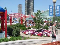
Photo 14:
Gateway, Chicago
Design Influence Opportunity
Making
obvious connections, such as a gateway, can also be made through institutional
support. For example, a new Kindergarten
through eighth grade Cleveland Municipal School District (CMSD) school is being
considered in the area south of Richner and north of St. Mary’s Cemetery
between West 30th and 41st Streets. This school could be a significant link
between the neighborhood and the Re-Cycle Corridor through its proximity and
focus on ecological education. The
school could support the corridor through its practices as well. The building could be built using green
building techniques. In order to get a
green built school, the residents would need to push CMSD to fulfill their
wishes. CMSD claims to be committed to
community involvement across the board with regard to the school building
portion of their master plan, so community involvement will be essential to
making a green school a reality.
Landscaping surrounding the school could flow as a contiguous journey
between the trail and Roberto Clemente Park (if expanded). While a landscape architect should be
consulted during the planning of the trail in general, such a consultant would
be most beneficial in this capacity where impact could be easily measured.
Measuring
the impact of establishing a relationship between the corridor and the school
will be easy. If teachers and trail
planners work together, the trail will be used as a teaching tool to support a
variety of subjects already being taught in the classroom. Use will be the measure of success. In addition, by creating a large, continuous
area with indigenous landscaping using urban ecology principles, the measure
will be a healthy environment that supports plant and animal life.
VII.
Residential and Retail Redevelopment
“Re-Cycle Corridor”
The
purpose of this section is to explore some options for residential and retail
development along the midsection of Train Avenue. Although such development,
particularly residential, may have been incompatible with the heavy industrial
uses of the corridor’s past, our eco-industrial vision of the corridor’s future
includes a variety of uses that will prove to be compatible with the light or
“new-industrial” uses that our plan intends to foster and preserve. Our
proposal seeks to employ three main principles: conservation of energy,
reduction of emissions, and social equity.
We begin our analysis by revisiting the relevant findings of Phase I of
this project:
Environmental
Site assessment[4]
The
area immediately surrounding Train Avenue was once an important component of
Cleveland’s industrial juggernaut. Breweries, slaughterhouses and heavy
manufacturing facilities surrounded the crucial rail lines that ran east and
west, to and from downtown Cleveland and beyond. Today, the industries along
Train Avenue are a shadow of what came before but, unfortunately, the toxic
byproducts of past industrial uses remain. Team A’s environmental maps identify
numerous Large Quantity Generator (LQG) and Treatment, Storage and Disposal
(TSD) sites that are registered with the EPA under the Resources Conservation
and Recovery Act (RCRA). [5]
Additionally, numerous leaking underground storage tanks dot the maps.
Currently,
most of the land that surrounds Train Avenue is either vacant or underutilized.
Phase I of this study described the nearby commercial corridors of Lorain,
Clark and West 25th Street as “struggling” and concluded that attempting
to convert Train Avenue into a commercial corridor would further handicap these
areas and not serve the best interests of the public. The study was more
optimistic with respect to new housing; several sites were described as “well
suited” for housing and that mixed-use developments may be feasible. The study
was inconclusive, however, about identifying a market area for housing and
concluded that market rate housing may price many of the economically depressed
area’s residents out of the market.
Sanborn Maps
Analysis
Many
of the sites marked for redevelopment along the central portion of Train
Avenue/Walworth Run had different uses throughout their history. The bullet points below give a glimpse of
how differently the land in this area of Cleveland was prior to the creation of
Interstate 90. According to the Sanborn
Insurance Maps:
§
The green shuttered
building at the corner of Vega and Train was the Cleveland Fruit Juice
Company. The maps note that this site
utilized steam heat, electric power, coal fuel and gas chemicals. It is a steel and brick structure that is
mostly fireproof.
§
The building that
currently houses a paper recycling plant is the former Leisy Brewery. This structure, with notable architecture,
is appears to be the only remaining structure from the former brewery, with the
exception of a smaller structure near W32nd that appears to have an unknown
use. The brewery was a sprawling campus
of sorts that straddled both sides of Vega Avenue. The maps note that this site utilized steam heat, steam and
electric power, and coal fuel. It is
also a steel and brick structure that is listed as mostly fireproof. This site seemed to have stored numerous
types of materials, some of which could have caused contamination. (This would explain its label as a RCRA and
LUST site—see below.) The map also
notes that there is a coal dump under the tracks that lead into the
building.
§
Just to the east of
the Leisy site, stands a building that was a former machine shop—which may
also prove to have environmental issues.
§
The building at the
corner of W 41st and Richner, which currently houses a tire company, was
originally a filling station—which may prove environmentally hazardous.
§
The corner of W30th
and Barber is the former site of the Cleveland Drycleaner and Dye Factory (a
very large facility)—which also indicates contamination issues. This site has one structure on the corner,
but the rest of the land is vacant.
(According to Cleveland’s Planning Commission GIS mapping website, the
home is in poor condition.)
§
West 30th
and Train Ave., the A&M Towing site, was the former home of a motor freight
station.
§
The Dobeckmun Company
made its home next to the Monroe Cemetery, at the corner of Monroe Avenue and
Fulton Road. Foils and Cellophane were
manufactured here. This site is
registered as a RCRA site.
§
Across from the
Dobeckmun Co. (west side of Fulton) was an auto parts store and salvage yard;
just north of this is a Jewish Cemetery.
The
maps also show a line showing where a natural cliff was. There are also various pipe widths recorded
in the middle of the streets.
RCRA
This
section contains excerpts from Group A’s reports that were tailored to the
Re-Cycle Corridor available at: http://urban.csuohio.edu/academics/graduate/mupdd/mupdd_capstone/team_a/teama_mid_report.htm
The
project site contains numerous locations that are registered with the EPA under
the Resource Conservation and Recovery Act (RCRA). RCRA is designed to provide “cradle-to-grave” controls by
imposing management requirements on generators and transporters of hazardous
wastes. RCRA applies mainly to active facilities that generate and manage
hazardous wastes. Facilities must
annually report to the EPA the quantities and types of hazardous wastes managed
on the property. One may request a
records report from the Ohio EPA’s Division of Hazardous Waste Management on
what types of hazardous materials are found at each site. As for clean up, there are specific closure
requirements the facilities must follow when they stop operating.
There
are eight RCRA sites directly relating to the central section of Train
Ave/Walworth Run Corridor Project. The
sites listed in the table below appear to have RCRA recognition. The sites listed in yellow are directly
related to the central part of the corridor.
The site listed in green is near the proposed school site.
|
TABLE 1 - RCRA SITES |
||||
|
|
|
|
|
|
|
NAME |
LOCSTREET |
LOCZIP |
|
|
|
DOWNING ENTERPRISES INC |
2400 FULTON RD |
44113 |
|
|
|
CLEVELAND PUBLIC POWER W 41ST ST SVC CTR |
2490 W 41ST ST |
44113 |
|
|
|
MINOR IJ CORP |
2621 W 25TH ST |
44113 |
|
|
|
SUNOCO SERVICE STATION |
2675 WEST 25TH ST |
44113 |
|
|
|
AMERICAN ELECTRO COATINGS |
2911 BARBER AVE |
44116 |
|
|
|
AMERICAN ENVIRONMENTAL COATINGS INC |
2917 BARBER AVE |
44113 |
|
|
|
PACKAGING CORP OF AMERICA |
3400 VEGA AVE |
44113 |
|
|
|
NORFOLK SOUTHERN RAILROAD |
WEST 27TH ST & SWIFT AVE |
44113 |
|
|
Restoring
brownfield sites can be quite costly, but several funds have been created to
help mitigate the costs; two of which are listed here. EPA Cleanup grants provide funding for a
grant recipient to carry out cleanup activities at brownfield sites. An
eligible entity may apply for up to $200,000 per site. These funds may be used to address sites
contaminated by petroleum and hazardous substances, pollutants, or contaminants
(including hazardous substances co-mingled with petroleum). An applicant must own the site for which it
is requesting funding at time of application or demonstrate the ability to
acquire title. More information can be
found at: http://www.epa.gov/brownfields/cleanup_grants.htm.
There
is also a Clean Ohio Revitalization Fund and the Assistance Fund (for
high-priority areas) that is a statewide grant administered through the Ohio
Department of Development’s Office of Urban Development in consultation with
the Ohio EPA. More information on this
fund can be located at: http://www.odod.state.oh.us/UD/CleanOhioFund.htm.
Leaking
Underground Storage Tanks (LUST)
There
are also four leaking underground storage tanks located within (one is very
near) the central portion of the corridor.
They are shown in the table below.
TABLE 2 -
LEAKING UNDERGROUND STORAGE TANKS
|
||||
|
|
|
|
|
|
|
Name |
Address |
City |
ZIP |
Status |
|
VACANT LOT |
2149 W 25TH ST |
CLEVELAND |
44113 |
Active |
|
NORFOLK SOUTHERN COGSVILLE CONNE |
25TH AND SWIFT AVE |
CLEVELAND |
|
Inactive |
|
PACKAGING CORP OF AMERICA |
3400 VEGA AVE |
CLEVELAND |
44101 |
Active |
|
TRUCO, INC. |
4301 TRAIN AVE |
CLEVELAND |
44113 |
Inactive |
Clean
up of these sties can be funded or at least supplemented through several
grants. The U.S. EPA has grants
available for petroleum brownfields and also has a “brownfields assessment,
cleanup, and revolving loan fund grant” as well as a “Leaking Underground
Storage Tank Trust Fund”. All of these
funds can be reviewed at the U.S. EPA’s website: www.epa.gov/oust/rags/index.htm.
There
is also a Bureau of Underground Storage Tank Regulations (BUSTR) operated under
the State Fire Marshall’s Office of the Ohio Department of Commerce. Their mission is to “Effectively regulate the safe operation of underground
storage tanks and to ensure appropriate investigation and cleanup of releases
from underground storage tanks for the purpose of protecting human health and
the environment for the citizens of Ohio.”
This would be a good starting point for anyone interested in the clean
up of leaking UST’s. https://www.com.state.oh.us/odoc/sfm/bustr/
Stakeholder
Surveys[6]
The
stakeholder surveys conducted in Phase I provided additional insights for new
development along the corridor. The consensus was that although Train Avenue
had significant problems, new housing might be the most feasible type of
development to serve as a catalyst for positive change. The stakeholders
welcomed the new housing being developed on the former Joseph Feiss/Hugo Boss
site and identified several other sites for strategically placed housing that would
take advantage of the corridor’s downtown skyline views and easy access to
major traffic arteries.
Residential
and Business Focus Groups[7]
The
consensus building efforts of Phase I also highlighted many of the attributes
that make Train Avenue a suitable area for new housing. Although the business
owners tended to focus on the well-documented negative aspects of the corridor,
the residents offered optimistic views of the surrounding neighborhoods,
identifying factors such as convenient location, interesting architecture and
great neighbors as positive attributes. When asked about new housing
preferences, the residents favored single and double houses with some cluster
and senior housing; apartments were viewed with disfavor. Affordability was a
primary concern with some residents expressing fears about the high housing
costs associated with gentrification. The main retail concern was a lack of
decent restaurants in the area.
Past
and Current Plans and Best Practices[8]
Phase
I outlined numerous plans and practices that served as inspiration and
guidelines for the proposals that follow. The local plans that factored most
significantly were the housing examples of Tremont Ridge Promenade and Slavic
Village’s St. Hyacinth Neighborhood Master Plan. Portland’s Central Eastside
Industrial District and St. Paul’s Phalen Corridor Initiative served as
examples of industrial districts that have successfully integrated housing and
industrial uses. Additionally the Local Government Best Practices Guide:
Redevelopment & Infill Projects offered many useful suggestions for
overcoming the financial and legal barriers to urban redevelopment projects.
The
Connecting Cleveland 2020 Master Plan offered many useful principles through
its commitment to developing “communities of choice” that feature mixed-use,
high-density and pedestrian-friendly neighborhoods. The plan’s emphasis on
offering a wide variety of housing choices, including affordable housing was
also included in our analysis.
Residential
Development Sites
The
housing component of this project explored a number of potential sites for
residential development. The unifying theme is the design principles. Ideally
all of the sites will be densely developed and built using green techniques. Other considerations include justifications
for public subsidies as well as issues of social equity.
All of the sites selected for this
portion of the project are currently zoned for general Industry. The City of
Cleveland Civic Vision 2000 land use has designated the parcels for light
industry. Industrial zoning, however, does not preclude residential
development; the authors envision these sites as better suited, over time, as
concentrated housing developments because of the assets that these sites
possess. See figure below
We identified three substantial sites:
The NEC site, The Forest City Foundry Site, and the A&M Towing Site site.
These sites provide approximately 18 acres of developable land, with additional
acreage added over time as the first phases of development encourage adjacent
residential and retail uses. The Foundry site and the area above the A&M
Towing site provide excellent views of the skyline and, if the plan is
implemented as proposed, a number of amenities. The table below shows
current uses, owners, and respective sizes of the potential development
parcels.
|
Train Avenue
Housing Site Data |
|
Table 1 |
||||
|
|
|
|
|
|
|
|
|
|
Foundry Site |
|
NEC Site |
|
A&M Towing |
|
|
Owner |
HCI Enterprises/ Norfolk Southern Railroad |
|
Brandon Partners |
|
A&M Towing |
|
|
Zoning |
General Industry |
|
General Industry |
|
General Industry |
|
|
Current Land Use |
Vacant |
|
Transportation/Utilities |
|
Heavy Industry |
|
|
Civic Vision Land use |
Light Industry |
|
Light Industry |
|
Light Industry |
|
|
Environmental Concerns |
LUST |
|
Hazardous TSD |
|
None |
|
|
Acreage |
8+ Acres |
|
7.63 Acres |
|
1.93 Acres |
|
A&M Towing
This site is located on the south side
of Train Avenue between W. 30th and W.32nd Streets and
bordered on the south by Barber Avenue. According to the data collected in
Phase I and the Sanborn Maps analysis (discussed above), the site is without
substantial environmental challenges. Because the area once contained a dry
cleaning operation, our plan anticipates some environmental problems with
developing the site. In the current plan the lower portion of the site is
slated as a wetland recovery area and park with a multi-use trail spur running
through the park connecting the housing on the both the Foundry Site and the
housing proposed in this section. The site-plan below shows the current
land-use on the left and the proposed use for this parcel on the right. This plan will call for the acquisition of 27
additional parcels. These parcels are mostly zoned as residential and 14 of
those 27 parcels are either land banked or vacant. This leaves 13 parcels to be
acquired, preferably through negotiation. We estimate that 45 housing units may
be created on this site.
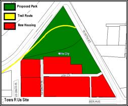
Current A&M Site
Proposed A&M Site
Forest City
Foundry Site
Immediately east of the A&M Towing site is the Forest City Foundry site. The
proposed housing for this section would be bordered on the east by W. 25th
street, on the west by 30th Street, on the north by Train Avenue,
and the south by Queen Avenue. The site consists of four contiguous parcels
owned by the Norfolk and Southern Railroad and HCI Enterprises. The authors
felt that an initial housing development within these contours would create a
strong base for either continued new housing development between Queen Avenue
and Barber Avenue, or substantial rehabilitation of the existing housing stock
in that area as property values increased due to the new developments.
Additionally, while the plan indicates that the housing extends to 25th
Street, this area would alternatively be left undeveloped to serve in the
future as convenience retail for the newly strengthened housing community.
Presently, the site is listed as containing leaking underground storage tanks.
After remediation, it is estimated that this site may accommodate 170 housing
units.
NEC Site
This parcel is not actually on Train Avenue, it is
located on Fulton Road and Monroe Avenue, and comprises nearly eight acres. It
is owned by the Brandon Partners and is a hazardous material storage site. A
subsequent section of this plan deals with brownfield remediation, and as a
result those issues will not be addressed in this section. The NEC Site would
be the most logical first step in developing housing because of its proximity
to a currently revitalized housing market in Ohio City. Presently, the proposed
NEC development is more market competitive than the other sites. If the
connection to Train Avenue can be emphasized then this development could be
among the first steps for creating momentum on the corridor. For example,
development of this site could happen first, next the multi-use trail
emphasizing connections previously severed by the railroad lines, third,
development of an Eco-Industrial brand and lastly, the development of the
remainder of the proposed housing. Hopefully the new housing, in proximity to a
multi-use trail, will create interest in Train Avenue and lead to support for
the other steps of the plan.
Housing Design
In keeping with our mission statement, the design of
the housing sites should be consistent with the principles of transit-oriented
design (TOD). An acceptable density for a TODs is 25 Units per acre with the
density increasing closer to the transit nodes. Here, the nearest station on
the red line is 25th and Lorain. However this does not mean that the
developments cannot be in keeping with TOD density. While not ideal, the train
station is still within one mile of the proposed housing sites. Additionally,
the multi-use trail spur will connect to the scenic byway on 25th
street, drawing housing users up the multi-use trail and into 25th,
and then to the train station. Additionally, the presence of a multi-use trail
will draw attention to the scenic byway and encourage its use so that the
scenic byway will become more alternative transport friendly. (i.e.
pedestrians, bikes, etc.) See figure below.
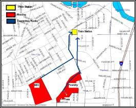
In addition to creating highly dense housing
developments to promote easy public transit commutes into the CBD, the
materials that comprise the actual houses themselves are important to achieving
the overall goals stated in the plan. Here, ideally by the time that these
plans are ready for implementation the standards for LEED (Leadership in Energy
and Environmental Design) environmental certification will have been in use for
long enough that market based housing can be developed accordingly. Presently
the cost over-runs due to compliance are often prohibitive. However, consider
the following statistics regarding building energy consumption. Buildings use
or generate:
- 36%
of total energy use
- 30%
of greenhouse gas emissions
- 30%
of raw material usage
- 30%
of waste output
- 12%
of potable water[9]
The
housing proposed here could begin to reverse some of these trends. The building
industry is an area that is unfortunately fraught with compromise because of
the importance of construction as a driver in the national economy. To require
green conformance may well cause a construction slow-down and the economy may
teeter toward recession. However, given the statistics above, an incentive must
be created to allow private developers to defray the cost of green compliance.
Incentives could come on the form of a tax credits for larger developments, or
a streamlined new energy tax credit. For example, in Hennepin County, Minnesota,
the County Board of Commissioners included $2,000,000 in bonding for Transit
Oriented Development (TOD) in the approved 2004 Capital Budget. TODs
supported with this funding must be in redevelopment areas, have
multi-jurisdictional impacts, and enhance transit usage. The criteria and
guidelines for this fund are designed to support both redevelopment and new construction.
Whatever the mechanism, the project as proposed
presently would require subsidies for both brownfield remediation as well as
green compliance. Given the number of years over which the plan is to be
implemented, it is possible that enough green building will be done between now
and then that techniques will improve to the point of market viability.
Given this assumption, the proposed projects will be
ones that advance the goals of sustainability by reducing energy use and
emissions by encouraging green building and reliance on public transportation.
Additionally renewable construction materials will cut down on over-all waste
outputs, and overall material consumption.
Justification for Subsidies
Public
subsidies for the proposed project can be justified on two alternatives bases.
Numerous studies have shown that housing located near trails, or green space is
more desirable than not, and some studies have indicated premiums of 5% added
to the value of a house based on its proximity to trails.[10]
This would mean that these new housing projects should sell for slightly above
market value and as a result produce significant property tax benefits for the
city. Additionally, Dr. Robert Simons has found that new housing developments
in the urban core have added an average $670 in value to each adjacent parcel[11].
In this case housing development will generate significant benefits because of
the increased values and property tax revenues.
Mixed Income
Another
necessity to achieve the goals of the plan is a mechanism to encourage diverse
economic communities. In the present case there are a number of alternatives.
One suggestion is for a Planned Unit Development. In this case the planned unit
development is able to determine its own zoning code, and will be able to
develop more densely than the zoning code allows, additionally the land could
be subject to a restriction that requires a certain percentage of the units be
set aside for low-income units. A preferable method of doing the same thing is
to create a zoning overlay. The zoning overlay could create the same sort of
restrictions and allow development in the same way as the PUD. In either case,
the integration of economic diversity advances an important goal of
sustainability by creating social equity.
Retail Development
We
began our retail market analysis by locating sites for potential retail
development. We concurred with Team A’s Phase I conclusion that Train Avenue
itself is currently unsuitable for commercial development, and decided instead
to focus on the traditionally commercial corridor of West 25th
Street which passes over Train Avenue via a four-lane bridge. As the photos
below indicate, the west side of West 25th Street from the Train
Avenue overpass to Barber Street is composed primarily of vacant lots with the
exception of a used car dealer and a few other small businesses. The area is
conveniently located in close proximity to the Foundry site, and would
certainly benefit from a housing development such as the one proposed in this
plan.

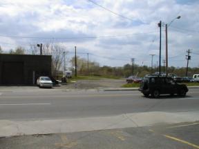

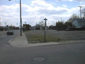
The
next step was to complete the retail niche analysis that was initiated during
Phase I. We used the data gathered on the one-mile radius from the central
portion of Train Avenue as our primary market area (PMA) for retail (see map
below). The PMA includes the neighborhoods of Clark-Fulton, Ohio City and parts
of Tremont, Detroit-Shoreway and Stockyards.
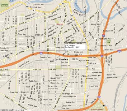


Using
an aggregate annual household income of $267,143,968 (household median income
of $25,816 multiplied by 10,348 households) and a capture rate of 40% our
retail niche analysis indicated that retail demand had been met or exceeded in
every category with the exception of general merchandise stores (see table
below). This result was not surprising considering the depressed economic
conditions of the area evidenced by the struggling commercial corridors of
Clark and Lorain. We expect this situation to improve, however, as demand for
new housing in the area is met and the population increases. That being said,
our feasibility study does not presently indicate opportunities for significant
retail real estate investments.
A
limitation of the analysis that must be mentioned is that the PMA included
areas south of I-90 that may not be captured due to the physical and
psychological barrier imposed by the interstate. We are unsure whether this
would have a positive or negative effect on the PMA.
Conclusion
The
residential and retail portion of this project is informed by the research done
in Phase I and this group’s mission statement. The proposal seeks to employ
three main principles: conservation of energy, reduction of emissions, and
social equity. The proposals, if enacted, will help towards those ends by
employing high density housing close to the urban core constructed with “green”
renewable materials. Legal covenants and zoning overlays will provide for
diverse housing choices. As the area’s population increases, we expect formerly
vibrant retail corridors such as West 25th Street to rebound,
providing locations for small businesses within walking and riding distance of
a multiuse trail and attractive, affordable housing.
VIII. Alternatives
Wouldn’t
it be great if the “Mistake on the Lake” made national headlines by creating a
unique, one-of-a-kind environmentally friendly inter-urban community? Wouldn’t it be great if that community could
also directly link into one of Ohio’s up-and-coming high technology
industries—thus capitalizing on a worldwide emerging market?
Fuel Cells
Fuel Cells could be that link. Imagine the Train Avenue/Walworth Run
Corridor (soon to be nationally known for its dramatic turn-around) as the
first urban community to be fully powered by fuel cells, homes and eco-friendly
industry alike. The Queen/Barber area
would be the perfect location to create this environmental community.
It would be picture perfect if combined with the
daylighting of Walworth Run. This would
pair the reclamation of history with the creation of history. One could even focus on community history by
potentially bringing a brewery back to the area. Funding for the project should be relatively easy to find if it
is actively promoted.
What
is a Fuel Cell? A fuel cell is an electrochemical energy
conversion device that converts hydrogen and oxygen into water, producing
electricity and heat in the process. It is very much like a battery that can be
recharged while you are drawing power from it. Instead of recharging using
electricity, however, a fuel cell uses hydrogen and oxygen.
|
|
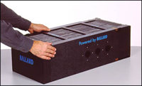
The fuel cell will compete with many other types of energy
conversion devices, including the gas turbine in your city's
power plant, the gasoline engine
in your car and the battery in your
laptop. Combustion engines like the turbine and the
gasoline engine burn fuels and use the pressure created by the expansion of the
gases to do mechanical work. Batteries store electrical energy by converting it
into chemical energy, which can be converted back into electrical energy when
needed.
A fuel cell provides a DC (direct current) voltage that can
be used to power
motors, lights or any number of electrical appliances. There are
several different types of fuel cells, each using a different chemistry.
Problems
with Fuel Cells: A fuel cell
uses oxygen and hydrogen to produce electricity. The oxygen required for a fuel
cell comes from the air. In fact, in the PEM fuel cell, ordinary air is pumped
into the cathode. The hydrogen is not so readily available, however. Hydrogen
has some limitations that make it impractical for use in most applications. For
instance, you don't have a hydrogen pipeline coming to your house, and you
can't pull up to a hydrogen pump at your local gas station.
Hydrogen is difficult to store and distribute, so it would
be much more convenient if fuel cells could use fuels that are more readily
available. A device called a reformer addresses this problem. A reformer turns
hydrocarbon or alcohol fuels into hydrogen, which is then fed to the fuel cell.
Unfortunately, reformers are not perfect. They generate heat and produce other
gases besides hydrogen. They use various devices to try to clean up the
hydrogen, but even so, the hydrogen that comes out of them is not pure, and
this lowers the efficiency of the fuel cell.
Some
of the more promising fuels are natural gas, propane and methanol. Many people
have natural-gas lines or propane tanks at their house already, so these fuels
are the most likely to be used for home fuel cells. Methanol is a liquid fuel
that has similar properties to gasoline. It is just as easy to transport and
distribute, so methanol may be a likely candidate to power fuel-cell cars.
- Solid oxide fuel cell
(SOFC): These fuel cells are best suited for large-scale stationary power
generators that could provide electricity for factories or towns. This
type of fuel cell operates at very high temperatures (around 1,832 F,
1,000 C). This high temperature makes reliability a problem, but it also
has an advantage: The steam produced by the fuel cell can be channeled
into turbines to generate more electricity. This improves the overall
efficiency of the system.
- Molten carbonate fuel
cell (MCFC): These fuel cells are also best suited for large stationary
power generators. They operate at 1,112 F (600 C), so they also generate
steam that can be used to generate more power. They have a lower operating
temperature than the SOFC, which means they don't need such exotic
materials. This makes the design a little less expensive.
This is a promising application that you may be able to order as
soon as 2002. General
Electric is going to offer a fuel-cell generator system made by Plug Power.
This system will use a natural gas or propane reformer and produce up to seven
kilowatts of power (which is enough for most houses). A system like this
produces electricity and significant amounts of heat, so it is possible that
the system could heat your water and help to heat your house without using any
additional energy.
http://www.healthandenergy.com/fuel_cells_for_homes.htm
talks about an area in New York that was a trial run.
The
information above regarding fuel cells came from the following site. http://science.howstuffworks.com/fuel-cell1.htm
Creating
a development powered by fuel cells would also fit in nicely with the Cuyahoga
Valley sustainability Principles listed at www.cuyahogavalley.net.
Capitalizing
on History: Create a Historic District
When
revamping an area, it is always best to start with what you have. The corridor has historically been a mixture
of housing and industry. While many of
the area homes are in relatively poor condition, several of them have
historical value. On average, they were
built around the turn of last century—mostly between 1880 and 1910.
Because
the area seems to be in somewhat a state of disarray, it would not yet seem
feasible to request that it be designated a historical zone like many of the
areas in and around nearby Ohio City.
Yet it would seem logical to explore the possibility of designating some
of the homes in the historic registrar.
This would help to promote reinvestment in the area.
The
possibility of consolidating the areas unique housing should also be
considered. Many urban areas have
relocated homes in an attempt to preserve their history while simultaneously
redeveloping the homes previous lot and maintaining the protection of the
public’s health, safety and welfare.
The links below are examples of how other urban areas dealt with
relocating homes.
http://interlinc.ci.lincoln.ne.us/city/pworks/antelope/pdf/houspres.pdf
http://www.lawa.org/html/LAWA_show_news.asp?news=363 (Los Angeles airport to sell, then relocate noise-impacted homes
to non-profits for affordable housing)
Industrial Corridor Alternative
While thinking of ideas for the Queen/Barber area, one
should not rule out the idea of a purely industrial corridor, as is proposed on
the Cleveland Civic Vision Draft. It
would provide much needed industrial space for the city of Cleveland, and would
be an ideal place for business due to its proximity to downtown.
Housing
Alternative
Housing
at the former N.E.C. site would blend in nicely with the existing housing on
Fulton. Yet this site would also
provide a wonderful opportunity to link the environmental initiative that is
taking place on Train Ave/Walworth Run to the historical and antique district
on Lorain Avenue. This site could
possibly house a tasteful storefront/warehouse for recycled housing materials
and products for resale (rehabbed doors, cabinet handles, windows, etc.)
Other ideas for
the corridor (with no specific locations) include: a driving range, batting
cages, a rock-wall gym, aerosol art area, and co-op gardening. A dedicated recycling area was also
proposed. This clever idea would take
advantage of the fact that this area has historically been a dumping
ground. In a sense, the area could
still be a site for garbage, but people would have to properly dispose of it.
IX. Implementation
Scenario: A Three-phase Plan
Goals
Short-term
Improve
the existing Train Ave to allow it to be used as a temporary commuter relief
corridor during ODOT’s upgrade of the Cleveland Innerbelt. Explore the possibility of mixed-use “New
Urban” communities in the Queen-Barber triangle and at the former NEC site
(Fulton and Monroe).
Long-term
Once
the Innerbelt project is completed, Northeast Ohio Regional Sewer District’s
preliminary work on the combined sewer upgrade project can begin, in
conjunction with parcel consolidations, ultimately allowing reconstruction of
Train Ave as a greenway and cobblestone boulevard with a separate multi-use
trail along a daylighted Walworth Run.
Design
Principles
Ultimately,
key areas would be mixed-use with compact urban form such as new urbanism or
transit-oriented development.
Connection nodes to area assets and neighboring north-south communities
would emphasize greenway connectors such as a multi-use trail and the boulevard
concept, with ecologically sustainable construction.
Notes
Encourage
political, business and public participation at all stages. Study the possibility of a
cross-jurisdictional city commission with potential legal authority (e.g., Port
Authority expansion, ORC 4582; Neighborhood Conservation Area, City Charter
Chap 323; BRD, City Charter Chap 303; Park District, ORC1545) to oversee all
components within each phase of project; consider “moving” the railroads.
Preliminary
Schedule:
Phase I, Years 1-7
- Locate existing and
alternative sites for NEORSD interceptors (combined sanitary & storm
sewers), City lateral sewers, and historic course of the Walworth Run
- Determine Train Ave
alignment to minimize conflict with future sewer locations and original
creek bed, identify areas for major repair (e.g., sewer bottleneck, damage
at W 30th, etc.), and mill/resurface existing Train Ave as
temporary commuter corridor; construct temporary connection between Train
and W 65th to encourage use as reliever route
- Repair existing
fencing, upgrade lighting, install traffic control devices as necessary
- Include sufficient
right of way on Train Ave’s south shoulder for multi-use trail to run with
the road; begin slope stabilization projects as appropriate
- Develop and
construct construction materials recycling facility as a core component of
the eco-industrial corridor and begin operation as soon as possible.
- Identify businesses
and property owners amenable to future relocation within area (including
Cleveland Public Power and railroad); educate them on eco-industrial
concepts and sustainable practices (involve WIRE-Net & Walworth Run
Industrial Park)
- Assemble funding,
design and construction components for potential mixed-use areas (e.g.,
Queen-Barber Community); conduct market analysis for housing (e.g.,
rentals, condos, seniors), retail, and commercial sectors
- Begin alternative
rail route identification process
- Begin right-of-way
(RoW) identification and option/acquisition negotiations
- Develop and place
inexpensive/temporary signage for appropriate locations to depict future
plans or concepts, scenery, connections, etc.
·
Prepare required land
use / zoning amendments, design guidelines, site review, green bldg codes, etc.
Phase II, Years 7-14
·
Begin acquisition negotiations
with relocation candidates; relocate businesses and property owners as
appropriate; begin site assembly for final phase
·
Close temporary
connection between Train and W 65th to reduce traffic on Train as
Innerbelt renovation project is completed
·
Exercise options &
construct new housing / mixed-use community in Queen-Barber area (i.e., City
Neighborhood Conservation Area) and at NEC site
·
Continue alternative
rail route identification; include rail corporations and political backers;
begin necessary acquisition and construction as soon as possible
·
Identify possible
alignments for new Train Blvd greenway and MUT; determine best alignment and
begin acquiring RoW
·
Identify appropriate
areas for daylighting of historic Walworth Run and Mill Pond and layout for new
sanitary and storm sewers, including potential sites for constructed wetlands
·
Conduct environmental
analyses on controlled properties
·
Continually upgrade
and maintain temporary project signage
·
Conduct design
competitions for boulevard concept, public art (e.g., under bridges), parks,
streetscapes, etc.
Phase III, Years 14-21
- Exercise options and
complete necessary business and property owner relocations
- Complete alternative
rail route construction; acquire/ prepare available rail RoW
- Begin construction
of new sanitary sewers, necessary new storm sewers with sections of
historic creek bed to be daylighted; begin constructed wetlands projects
(e.g., site of original mill pond, west end of area near W 65th
- Begin construction
of new cobblestone Train Boulevard and MUT; incorporate customized
signage, lighting, art and amenities unique to area; develop MUT nodes
(separate from traffic-dependent areas) that emphasize recreation, the
environment and historic nature of the corridor as well as its connections
to other communities (e.g., Tremont Ridge, the Stockyards, Eco Village,
etc.)
- Offer development
incentives for specified areas along corridor that encourage sustainable,
mixed-use development to eventually expand the tax-base
X. Conclusion
We set out to transform Train Avenue
into an eco-industrial corridor that integrates residential living
opportunities, green spaces for recreation and new business innovations. We
hope to draw on the historic character of the valley and re-create natural
environments that have been altered over the decades. Neighborhood connections
can be established so that area residents can access the Towpath Trail and
other community assets. Our proposal
meets this vision with the following themes and elements:
Eco-Industrial
Concept
Our vision for an eco-industrial
corridor connects industrial uses and renewable resources. The eco-industrial
principles can act as an economic development catalyst to support a healthy
valley and invite people to experience a place of innovation where nature and
industry converge.
Trail Alignment
and Connections
A multi-use trail proposal for the south
side of Train Avenue will allow numerous connections to neighborhoods and
community assets.
Designing the
Corridor
- Identified the most
necessary design improvements for the short-term to address environmental
and safety concerns
- Design elements such
as signage, lighting and public art serve as a branding mechanism
- A new school may be
built near the corridor - a
potential link between eco-industry and the community
Environmental
Considerations
- Walworth Run stream
was buried - allowing sewage and rainwater to flow into the river
- Day lighting the
stream will alleviate current negative environmental conditions and
provide the opportunity to return the area to a more natural and
ecologically sound environment
Residential &
Retail Development
Residential projects have been proposed consistent
with the principles of Transit-Oriented Design emphasizing green materials,
building techniques and economic diversity. Currently there is no unmet retail
demand, but new housing will create opportunities for new retail.
Alternative Ideas
- Capitalize on area
history
- Explore options of
additional recreation
- Eco-friendly housing
- Potential
specialized retail
The
opportunity to realize a new Train Avenue begins with the framework of the
Cuyahoga Valley Initiative and the Connecting Cleveland 2020 Citywide
Plan. But there is one vital component
necessary for these opportunities to be translated into a vision: community commitment.
It is to the residents and businesses that we look to in the coming months;
without their input, without their willingness to move forward, there can be no
next step. Without committing to a
common vision, no proposal will ever be realized, and no opportunity ever
capitalized upon. It is with the hope
that such commitment is forthcoming that we submit this proposal, 11 May, 2004.