| Introduction | Project Summary | Study Areas | Reports, Presentations and Downloads | The Project Team |

Generally, the microgrid would be situated in the heart of Cleveland, Ohio, however, determining study areas requires an examination of land use patterns.
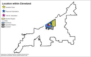
 Cleveland exhibits a series of sharp breaks in land use that serveto readily demarcate reasonable study areas. The initially proposed study extented from the Cuyahoga River to E. 55th, West to East and from Lake Erie to Carnegie, North to South. In order to allow for closer analysis this area was divided into a western Downtown section and an eastern Industrial section. These sections are divided by the section of I-90 running north-south through the center of the study area.
  The presence of items worthy of closer ananlysis immediately south of the initial study area prompted the creation of a third study area. The unique needs and opportunities of this section indicated that it was best studied in terms of its impact on the full study area. The southern section and the full initial study area constitute the Expanded study area. These three regions highlight different aspects of the community.

Downtown
The Downtown section extends from the Cuyahoga river to I-90 in the East. It extends from Lake Erie to Carnegie, North to South. This area represents the core of the central business district with a large number of office and residential towers. This section features a district energy utility providing steam and chilled water, making it particularly suitable for the development of data centers. Large existing power users include data centers, a university, and office towers. Developable sites are limited, largely consisting of commercial parking lots. This area has the highest density of large users and additional amenities which appeal to classes of high demand users, like data centers, but the region suffers from a paucity of develop-able space.
Industrial
The Industrial section extends from I-90 to E. 55th West to East and from Lake Erie to Carnegie, North to South. The eastern section largely consists of single family residential homes and low warehouses. This region features a large number of vacant buildings. In addition to the large number of vacancies a large number of low value properties are for sale and could be used for development. This area suffers from long distance to serve new customers the need to cross an interstate to serve the market, but benefits from a strong development potential.
Expanded
The Expanded section includes the Industrial and Downtown Sections plus an additional region extending South of Broadway to a set of railroad tracks, extending from the river to E. 36th. This larger area includes the assets of the Downtown area and the developable sites of the Industrial area. The added area brings in a large government owned roof suitable for solar power and several large potential institutional users. This study area also brings a hospital, a community college, and a prison into the microgrid area. All of these users require special consideration individually but are possible long-term users. The Extended area also houses a large region of public housing. Public housing differs from other residential users due to the additional risk borne by the governing agency if unreliable power causes difficulties for residents. The region has a near zero amount of developable space, but marks the beginning of a large region of refrigerated warehouses which may serve as a strong commercial anchor for the project.

